Caltrans is in the early-to-mid stages of a roadway renewal project for the troubled 4-lane section of El Camino Real extending from San Mateo through Burlingame, and ending at Millbrae city limits. The section has issues with bicycle/pedestrian safety, flooding/drainage, and tree health on the corridor. El Camino Real is a critical transportation corridor that has long been unsafe for pedestrians and bicyclists, with bikes forced to ride on uneven sidewalks. These sidewalks cause tripping hazards for pedestrians. Intersections have limited sight distance and high vehicle speeds. ECR has high bus ridership, but travel times for riders are greatly affected by traffic congestion. Read on for project background and the alternatives that Caltrans is currently considering. Also read on for how you can advocate for not closing the door on bus infrastructure and press Caltrans to include bike lanes in the alternatives.
The best solutions for transit and active transportation would be maintaining the width of the roadway at 44-46 feet. This roadway width would allow for bus lanes to be considered in the future, and would still allow for bike infrastructure and traffic calming measures like a road diet to be considered and implemented while the longer process of studying bus infrastructure takes place. This kind of strategy would help move forward on pedestrian safety by reducing the speed of traffic, advance climate goals by disincentivizing auto use/encouraging bike ridership, and prod Caltrans to consider the potential for bus lanes. Some prompts/talking points to consider (see the further below in this blog for more explanation of the alternatives):
- El Camino Real is dangerous for bicyclists as well as pedestrians – therefore, bike lanes/infrastructure should be included as an element in this project.
- All of the alternatives should be re-evaluated to determine what bike lanes would look like on the corridor. Alternatives 3 & 4 could easily accommodate bike lanes if the roadway width were not reduced.
- Caltrans should make sure that any selected alternatives do not prevent bus lanes from being implemented on this crucial transit corridor in the future
- Caltrans should detail what traffic calming measures would be taken in all of the alternatives, but especially alternatives 1 & 2, which do not come with the speed-reduction effects of a road diet. Alternatives 1 & 2 do preserve the potential for including bus lanes in the future, which does make them more desirable than alternatives 3 & 4 as currently depicted (without bike lanes and with a reduced roadway width).
- If alternatives can be added to this project, it would be useful for Caltrans to consider and describe what dedicated bus lanes on El Camino would look like (i.e. if there were to be a bus lane on El Camino eventually, this is where it would go, etc.). It would be bad to close off the possibility of doing that permanently.
Summary of events and actions you can take at this time:
- Please leave comments on the forum encouraging Caltrans to consider what a multi-modal corridor would look like. Be sure to check out the “roadway” and “alternatives” section, and the comments that are already there. You can upvote/downvote comments you agree/disagree with. For more info on the alternatives, the potential impact on future bike infrastructure/bus service on El Camino, as well as prompts for comments, read below. Comment Period CLOSES this Friday, January 8th! You can also provide comment directly to Caltrans by emailing ecrproject@dot.ca.gov.
- Citizens Environmental Council is hosting an online event (you must register here) with members of the Burlingame ECR Task Force TODAY, Jan. 6th at 7 pm. This will be an opportunity to ask questions about the project alternatives and impress upon task force members the importance of accommodating bikes, pedestrians, and transit on the corridor.
Project Background
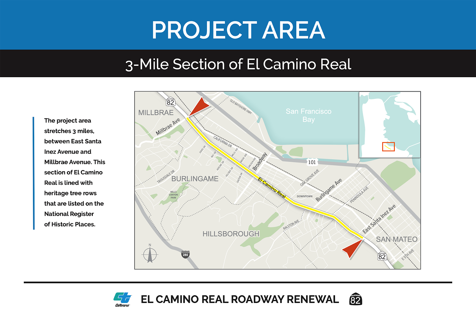
Stakeholders involved in the project include the Cities of Burlingame, Hillsborough, San Mateo, and Millbrae. Also listed as a stakeholder is the El Camino Real Task Force, created by the city of Burlingame. A review of the task force documents sees little to no mention of bicycles/transit being considered, although there was focus on pedestrian safety. The main focus of the task force seems to be the preservation of historic trees on the corridor.
While the mitigation of design impacts to the trees should be considered, there has not yet been enough advocacy for ensuring multimodal use of the corridor, and preventing El Camino in Burlingame from becoming a bottleneck to better regional bus service and bicycle infrastructure on the peninsula.
According to a video on the Caltrans project website, the spring 2021 draft environmental document will include: a discussion of every alternative, further study of the alternatives they think most suitable, and then further explanation of what they deem to be the most viable alternatives.
The Alternatives:
Caltrans has released four conceptual alternatives. They differ in three major ways: placement of utilities (above-ground or below-ground), width of the roadway, and number of lanes. All alternatives call for sidewalk improvements. Alternatives 1 & 2 retain 4 travel lanes and keep the same roadway width as today (44-46 feet). Alternatives 3 & 4 would implement a road diet with center left-turn lane, and reduce the width of the roadway by 8 feet. Instead of adding bike lanes in the space created by the road diet, alternatives 3 & 4 call for expanded tree areas, which would allow for the preservation of more trees but would do so at the expense of bicycle safety. While transit infrastructure was not part of the project scope, a narrower roadway would make it more difficult to implement bus lanes/faster bus service on El Camino in the future, although a bi-directional bus lane could still be considered instead of the center left-turn lane.


If you’d like to preserve the potential for bike and bus infrastructure, you can provide comments on the Caltrans forum for this project. You can also upvote comments that you agree with. The goal is to have as many upvoted comments as possible supporting bicycle, bus, and pedestrian infrastructure on the corridor, to hopefully prompt Caltrans to reconsider the inclusion of bike lanes as well as take into account faster bus service when selecting alternatives.